| Distance | 6.6 km return (coastal track only) |
| Time | 2 to 3 hours |
| Difficulty | Moderate |
| Route | Return or loop (see below) |
| Elevation gain | 160 m |
| Dogs | No (scenic reserve) |
| Toilets | Yes, at the campground |
| Parking | Yes, at the beach |
| Mobile coverage | Yes |
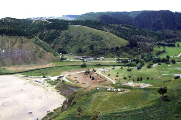
Waipatiki Beach is a cracker of a spot about 40 minutes north of Napier, tucked into a cove with towering limestone cliffs and native bush right behind it. Most people come for the beach but there’s a good coastal walk here too, north along the cliff tops to Aropaoanui Beach and back. I did this walk years ago and pushed on further over the ridge with permission from the local elder, which added a couple of hours but was one of the best views I’ve had on the Hawke’s Bay coast.
Getting there
From Napier take SH2 north for about 32 km, turn right onto Tangoio Road at the Waipatiki Beach sign, then left onto Waipatiki Road and follow it 12 km to the beach. The road is winding and narrow in places, watch your speed. There are speed humps just before the beach.
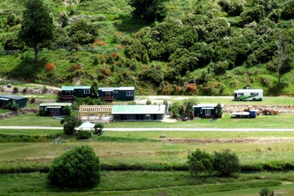
Park at the beach picnic area at the end of Waipatiki Road. Toilets are at the campground nearby. There’s no shop at the beach so bring everything you need.
The walk
The standard walk: Waipatiki to Aropaoanui Beach and back
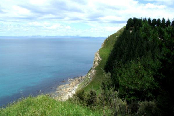
From the picnic ground, walk to the northern end of Waipatiki Beach and look for the white clay track heading up the cliff face. There are no track signs so keep an eye out for it, it’s visible from about halfway along the main beach. The track is well used once you find it.
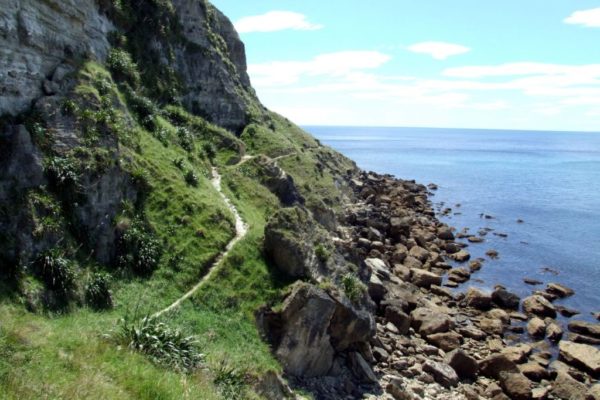
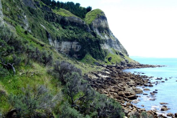
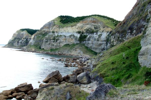
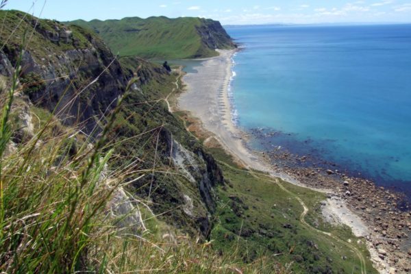
The coastal track follows the cliff face north with good views back over Waipatiki Beach and south to Cape Kidnappers. It’s exposed with no shade so go early on a hot day and take plenty of water. There’s no easy swimming along this section as the rocks below are large and sharp, you’ll have to wait until you reach Aropaoanui Beach.
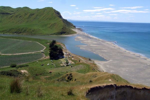
The walk to Aropaoanui takes about 1 hour 10 minutes covering around 3.3 km. Aropaoanui Beach is a quiet remote beach at the mouth of Aropaoanui valley. Have a swim, have lunch, and head back the same way. The return is about 2 hours 20 minutes total.
Important: Aropaoanui valley is on Maori land. Please stay on the beach and do not walk onto the land without permission.
The longer loop: over the ridge with permission
I asked the elder at Aropaoanui village if I could walk back to Waipatiki along the cliff face above. He was happy I’d asked first and gave me directions around the trickier sections. This is worth doing if you can get permission, the views from the top at 160 m are tremendous, right up and down the coast.
It adds about two hours to the walk and is significantly rougher. There’s no track, just open grassy paddocks and gullies. When you reach a gully it’s easier to walk inland about 200 m rather than fight through the scrub at the bottom. Keep close to the cliff face on the ridgeline. Wear long pants as the gullies have scratchy vegetation. The descent back down to Waipatiki is steep grassy hillside, slippery if wet.
You need permission before attempting this section. Do not assume you can do it without asking first.
Good to know
Waipatiki Beach itself is a good swimming beach with a lifeguard in summer. There’s a fresh water creek at the back of the beach that’s great for kids. The Waipatiki Beach Holiday Park is right there if you want to make a night of it.
The Waipatiki Scenic Reserve just before the beach also has a short steep bush walk through kahikatea and nikau palm groves up to a lookout with views of Cape Kidnappers. You’ll see rare NZ coastal bush with kahikatea trees up to 600 years old, nikau palms and other native species, and birdlife including kereru, fantails, tui and bellbirds. Dogs are not allowed in the scenic reserve but are allowed on the beach on a leash.
Watch the weather. The coastal section is fully exposed and unpleasant in strong wind or rain.
Other walks nearby
- White Pine Bush Reserve walkway is another good Hawke’s Bay bush walk
- Lake Waikaremoana for a multi-day great walk in the region
- Napier walks for more options in the area
