5km loop from Te Haruhi Bay, red markers, cliff-top views of Tiritiri Matangi Island, Pink Beach at low tide, WWII degaussing station. No dogs. Complete route guide.
Shakespear Regional Park is at the very tip of the Whangaparaoa Peninsula, 50km north of Auckland. The Tiritiri Track is the coastal one , red markers, rolling farmland, cliff-top views across to Tiritiri Matangi Island, a stop at Pink Beach, and the WWII degaussing station that most people walk straight past without knowing what it is. It’s the most varied of the park’s tracks and my favourite of the three.
Distance
5 km loop
Time
1.5 to 2 hours
Difficulty
Easy to Moderate, some hills
Track surface
Grass paddocks, gravel, some steps
Starting point
Te Haruhi Bay car park, Shakespear Regional Park
Dogs
Not allowed, open wildlife sanctuary
Toilets
Yes, at the campground
Parking
Free at Te Haruhi Bay
Mobile coverage
Yes
Camping
Yes, bookable through Auckland Council parks website
Getting There
From Auckland follow SH1 north to the Silverdale off-ramp (about 26km), go through Silverdale and turn right onto Whangaparaoa Road. Continue for 12.3km to the end of the peninsula and follow the signs to Shakespear Regional Park. About 40 minutes from the city.
By public transport, take the NX1 north to Hibiscus Coast Station, then the 982 bus toward Gulf Harbour. Get off at 2 Shakespear Road and walk along Whangaparaoa Road to the park entrance.
Nearest cafes are at Gulf Harbour, about 4 minutes by car.
The Route
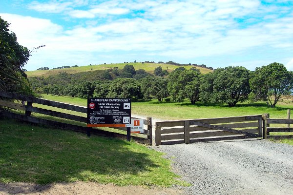
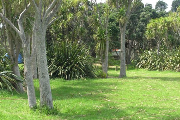
Main Gate at the start of the Shakespear Regional Park walkStart at the Te Haruhi Bay car park, step over the gate and walk through the campground to the toilets
Through the camp ground at the start of the walk
Use the toilets here, it’s the last ones on the track
Look for the red marker post past the toilets, head toward the hill and the steps up to the farmland
Option two, walk up the beach, turn left at the end and follow the steps up the hill
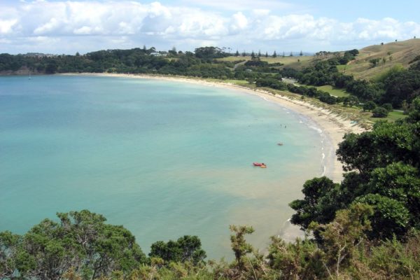
Views out to Te Haruhi Bay
At the top of the first point, sit down and enjoy the view back over Te Haruhi Bay, it’s a great lunch spot if you started early
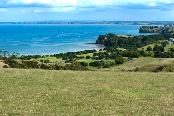
Continue along the cliff line following the red markers, views of Tiritiri Matangi Island open up from here
About 35 minutes in you’ll reach the WWII ship degaussing station, a dark green building on the east coast of the park near Pink Beach. Most people walk past it. It was built to remove the magnetic field from ships so they could pass safely over mines in the Hauraki Gulf
Just past the degaussing station the track turns inland, but if you continue straight you’ll reach the steps down to Pink Beach
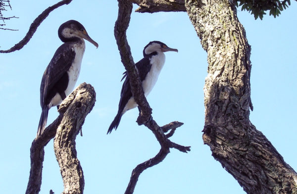
Shags resting in a tree at Pink Beach
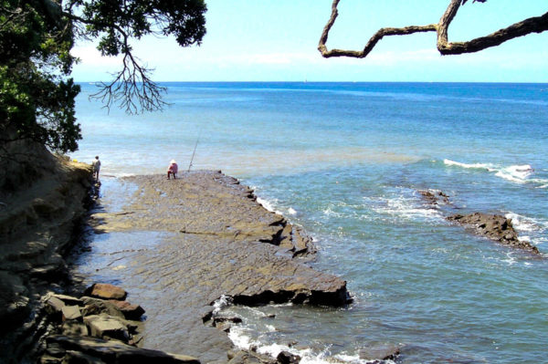
Pink Beach — not really a beach, layers of flat hard sandstone and rock. Easy enough to walk on but slippery. Low tide only access down the steps. Popular fishing spot. If you stop on the wooden deck, watch out for the birds sitting above you in the trees, you could end up with fertilizer on your sun hat
Fisherman at Pink Beach
Head back up to the red markers and continue to the lookout
The lookout is about 1.5km from the start, a short steep workout for 10 minutes. The security fence at the top belongs to the Ministry of Defence, so keep out, unless you’d like free accommodation for a few days. I know the food is great and the beds are hard, I’m ex-Army
The lookout on the Shakespear Regional Park walk
Excellent views from the top. Binoculars are handy. On a clear day you can make out Auckland City
Follow the red markers back down to the car park, or connect to the Lookout Track (blue markers) or Heritage Trail (yellow markers) from here
Good to Know
No dogs at all — fully fenced open sanctuary with pest-control gates. Dogs aren’t allowed even in cars on the road through the park. People get fined
Pink Beach is low tide only — check the tide times before you go, the steps down are steep and the rocks are slippery
No shade — almost the entire track is exposed farmland, bring water and sunscreen
Birds — white-faced herons, stilts, dotterels, tui and kereru are all common. Binoculars are worth it
Lambs in spring — the park runs sheep and cattle, you’ll walk through paddocks with animals
Camping — bookable through the Auckland Council parks website, separate area for self-contained vehicles
Drinking water — available in the campground and picnic area
History
The Ngati Kahu iwi occupied the Whangaparaoa Peninsula for close to a thousand years before European settlers arrived in the 1820s. Archaeological surveys show two main living sites at Army Bay and Te Haruhi Bay. W.H. Shakespear purchased 800 hectares at the tip of the peninsula in 1883. In 1910 the family built a homestead, now the YMCA Lodge, overlooking Te Haruhi Bay on ground that still shows evidence of a Maori pa. During WWII the army acquired 130 hectares of the northeastern tip. Defences included 11 pillboxes, searchlights, electrified barbed wire and an anti-tank ditch, plus the degaussing station on the east coast. The Auckland Regional Authority purchased the park from the Shakespear family in 1967.
Other Walks in Shakespear Regional Park
Heritage Trail — yellow markers, bush, waterfall, WWII gun emplacement and the lookout
Lookout Track — blue markers, shorter and more direct to the lookout
Ōkoromai Track — connects Ōkoromai Bay to Te Haruhi Bay through native bush and farmland
Kanuka Track — green markers, good alternative route through the park
For the Shakespeare Regional Park walks your website says Dogs on Leads – this is incorrect. There are NO DOGs allowed at all in Shakespeare Regional – it is a wildlife santuary with controlled pest gates. People will be fined for having a dog even sitting in the car. Please update your site

2 Responses
For the Shakespeare Regional Park walks your website says Dogs on Leads – this is incorrect. There are NO DOGs allowed at all in Shakespeare Regional – it is a wildlife santuary with controlled pest gates. People will be fined for having a dog even sitting in the car. Please update your site
Hi Rachael, thanks so much for letting me know about the situation regarding dogs in the park. I’ve updated the site now.