The main access point for Mangemangeroa Reserve is at 108 Somerville Road in Howick. If you’re driving from central Auckland, take the Southern Motorway to the South Eastern Highway exit, follow Route 10 to Ti Rakau Drive, turn right and continue past Botany Town Centre. Turn left onto Chapel Road, right onto Whitford Road, then a hard left onto Somerville Road. There’s parking available along the street near the entrance.
Alternative access points include Shelly Park Beach at the northern end and Hayley Lane for the southern track. Each entry point offers slightly different experiences of the reserve.
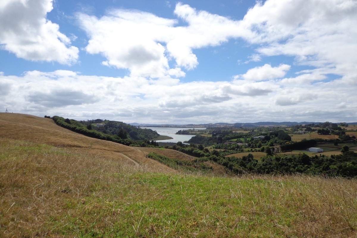
 The Northern Leg: Somerville Road to Shelly Park
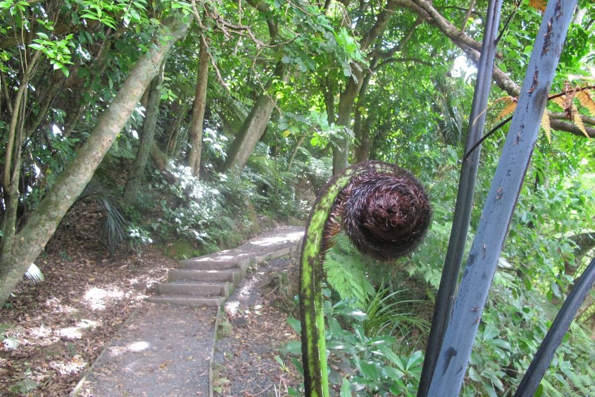
This is the most popular section and for good reason. The track has undergone significant upgrades in recent years with excellent boardwalks, well-formed steps and clear signage. You’ll climb through regenerating native bush with interpretive signs identifying local flora species.
The ridge walk provides stunning valley views down to the estuary. On a clear day you can see across to the Hauraki Gulf islands. The descent to Shelly Park involves 162 wooden steps, but they’re well-constructed and manageable for most people. Take your time and enjoy the canopy overhead.
👉 👉 Freedom Camp Between Walks – Hire a Campervan – We’ve got the best deals
Here’s something many visitors don’t realise: you can turn this into a 5km loop by walking from Somerville Road to Shelly Park, then returning along Pohutukawa Avenue, Sandspit Road and Somerville Road back to your starting point. It adds about 20 minutes of suburban road walking but gives you a circular route without retracing your steps through the bush. The road section is quiet and residential with ocean glimpses.
The southern track exiting at Hayley Lane is less well-known but equally rewarding. This 3km loop exits via Hayley Lane (a 150-metre laneway that climbs about 20 metres, so expect a short steep section). You can return along Point View Drive creating another satisfying circuit. This route sees fewer walkers and offers more solitude if you’re after a quieter experience.
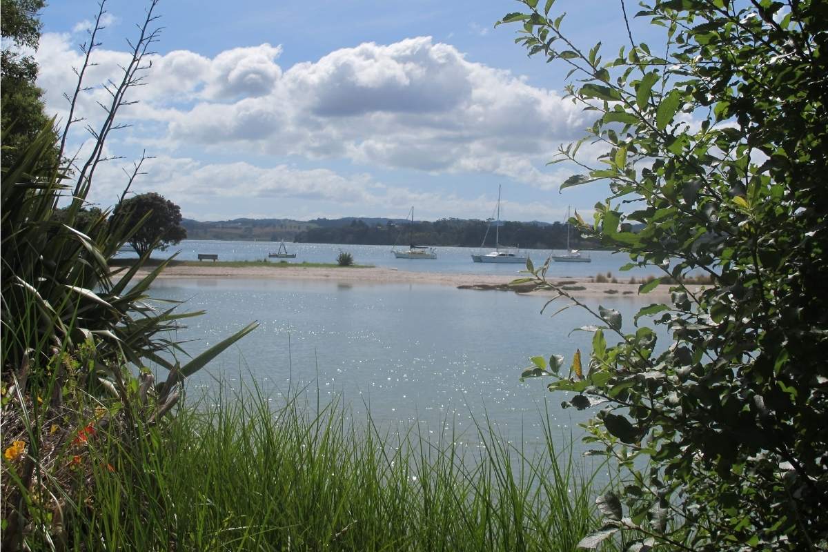
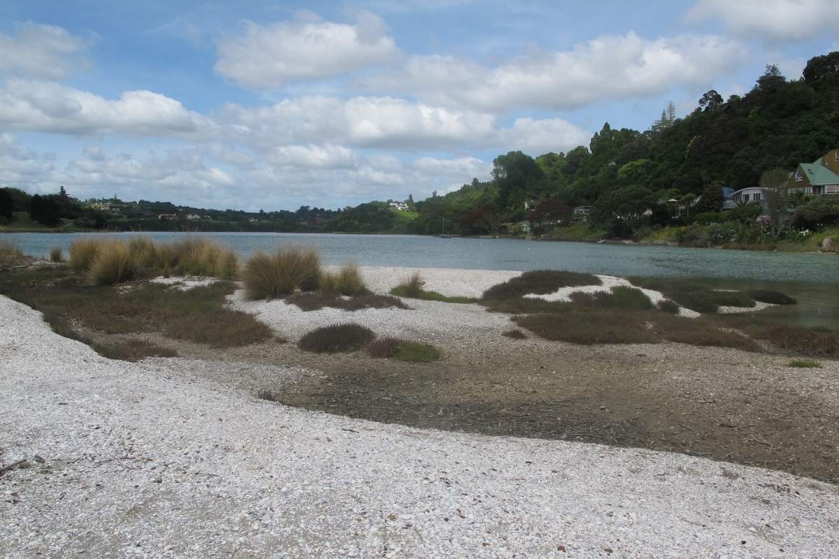
The Mangemangeroa Stream creates extensive mudflats that stretch along the estuary toward Cockle Bay. At low tide the exposed mud becomes a feeding ground for numerous wading birds including oystercatchers, herons and godwits. Historically ferries navigated through this creek but now mangroves have colonised much of the area creating important habitat for juvenile fish, crabs and shellfish.
Bring binoculars if you’re a bird enthusiast. The mangrove edges and mudflats provide exceptional birdwatching opportunities particularly during spring and autumn migration periods.
The track quality varies depending on which section you tackle. Recent upgrades mean most of the northern section features excellent infrastructure including:Extensive boardwalk sections through wetland areas
Some sections remain natural dirt track which can become muddy after rain. The reserve sits in a valley so drainage is slower here than on exposed ridgeline walks. Wear proper walking shoes or boots rather than jandals, even though you’ll see locals in all sorts of footwear.
This walk offers excellent wind protection when Auckland’s westerlies are howling. The valley location and dense bush canopy create a sheltered microclimate perfect for days when exposed coastal walks would be unpleasant. That said, the sheltered position also means less air movement on hot summer days so pack extra water when temperatures soar.
After heavy rain some sections can become quite slippery, particularly the wooden steps and boardwalks. The steps dry quickly but early morning dew can make them treacherous. Take extra care if walking in winter months when frost occasionally affects shaded sections.
👉 👉 Freedom Camp Between Walks – Hire a Campervan – We’ve got the best deals
The reserve protects an important corridor of coastal native forest. You’ll walk beneath puriri, pohutukawa, taraire and kohekohe trees. The understorey includes kawakawa, mapou and nikau palms. This is regenerating bush rather than pristine forest so you’ll notice different age classes of trees and ongoing succession.
Look out for native birds including tui, kereru (wood pigeon), fantails and grey warblers. Early morning walks offer the best chances for bird activity when they’re most vocal. The thick vegetation provides cover for smaller species that you’ll hear more often than see.
Dogs are welcome on leash throughout most of the reserve. However Auckland Council imposes restrictions on the shoreline during bird breeding season to protect nesting shorebirds. Check current regulations before bringing dogs during spring and summer months. The breeding season typically runs from September through February but specific closures are signposted at access points.
The track itself is excellent for dogs with varied terrain, interesting smells and shaded sections. Bring water for your dog, especially in summer, as there aren’t reliable drinking water sources along the way.
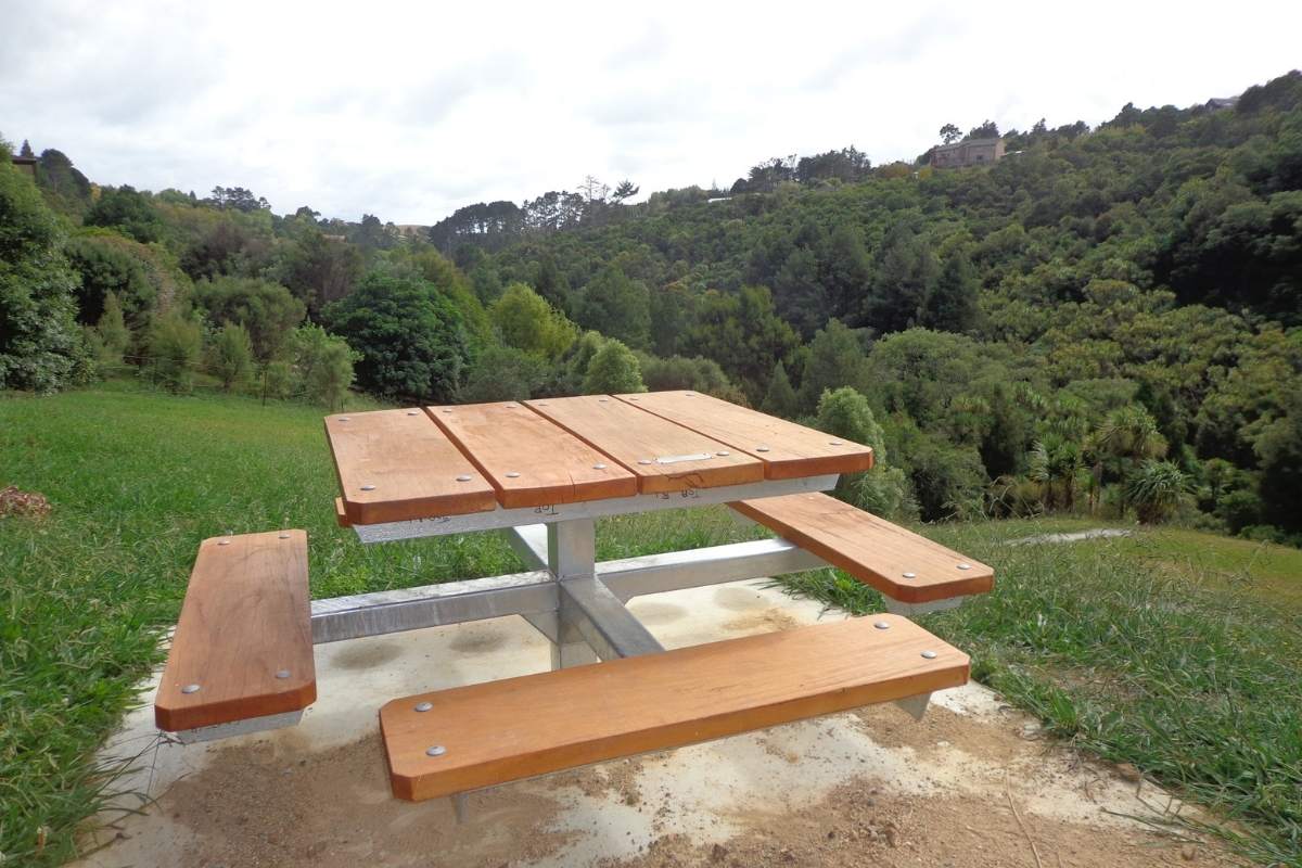
Shelly Park at the northern end of the track provides the best facilities including toilets, picnic tables and a children’s playground. The beach area offers safe swimming in summer and the yacht club adds interest to the waterfront scene. This makes Shelly Park an ideal spot to finish your walk with a picnic lunch or a swim.
The Somerville Road entrance has limited facilities but the nearby Howick Village (about 2km away) offers cafes, shops and public toilets. If you’re walking on Saturday morning consider timing your finish to coincide with the Howick Village Markets which run from 8am to 12:30pm. It’s a brilliant local market with fresh produce, crafts and food stalls.
East Auckland offers several other excellent coastal and estuary walks within easy driving distance. The Pakuranga Coastal Rotary Walkway lies just north and provides another easy waterfront walk with different perspectives of the Tamaki Estuary. Both walks can be completed in a single morning if you’re energetic.
For something more extensive, the Tapapakanga Regional Park walk offers coastal farmland walking about 30 minutes south. If you fancy heading west instead, the Awhitu Regional Park walk on the Manukau Harbour provides dramatic black sand beaches and clifftop views.
👉 👉 Freedom Camp Between Walks – Hire a Campervan – We’ve got the best deals
The varied environments within this compact reserve offer diverse photography subjects. The ridge viewpoints provide expansive landscape shots across the valley and estuary. Dense bush sections with dappled light create moody forest scenes. The mudflats and mangroves at low tide offer interesting textures and patterns, especially in late afternoon light.
Bring a telephoto lens if you’re serious about bird photography. The estuary attracts wading birds that are approachable from the shoreline sections without disturbing them. Early morning light on the mudflats creates beautiful warm tones and long shadows.
Despite being rated easy to moderate, this walk does include some elevation gain and substantial steps. The northern route involves those 162 steps down to Shelly Park which you’ll need to climb if returning the same way. The southern Hayley Lane exit includes a steep 20-metre climb over 150 metres.
Most people with average fitness will manage comfortably but it’s not suitable for wheelchairs or pushchairs. The steps, narrow sections and uneven surfaces make wheeled access impossible. If you’re bringing young children they’ll need to be confident walkers or carried in a backpack carrier.
The walk takes most people between 1 and 2 hours depending on your pace and chosen route. Starting early morning offers several advantages including cooler temperatures, better birdlife activity and easier parking. Weekends can get busy particularly Saturday mornings when locals combine the walk with the Howick Markets.
Low tide provides the best mudflat views and birdwatching opportunities. Check tide times before heading out if this interests you. The difference between high and low tide dramatically changes the estuary appearance.
This is a very safe urban walk but standard precautions apply. Let someone know where you’re walking and when you expect to return. Carry a charged mobile phone although coverage is generally good throughout. The steps can be slippery when wet so take extra care in damp conditions.
Stay on formed tracks to protect the regenerating vegetation and avoid disturbing wildlife. The cliffs and steep sections have adequate barriers but supervise children near edges. If walking alone tell someone your plans, although you’ll likely encounter other walkers most days.
Each season brings different rewards to Mangemangeroa Reserve. Spring sees the bush come alive with new growth, flowering trees like puriri attract tui, and migratory wading birds arrive at the estuary. Summer offers the warmest weather and the chance to combine your walk with swimming at Shelly Park.
Autumn provides comfortable temperatures and the pohutukawa trees begin preparing for their December flowering. Winter delivers crisp clear days with excellent visibility across the estuary and gulf. The lower sun angle creates beautiful light for photography. While some might consider winter less appealing, experienced walkers often prefer it for the solitude and atmospheric conditions.
If you’re looking for variety, several other excellent walks lie nearby. The Ambury Park Farm walk offers a completely different experience with farm animals and Manukau Harbour views. For bush enthusiasts, Waiatarua Reserve provides more extensive native forest walking in the Waitakere Ranges.
While the reserve borders the estuary, the muddy nature of the shoreline makes swimming unappealing. However Shelly Park Beach at the northern end provides a proper swimming beach with sandy areas at high tide. This is a much better option for swimming after your walk.
Yes, mobile coverage is generally good throughout the reserve as you’re still within suburban Auckland. However some valley sections may experience reduced signal depending on your provider. Don’t rely entirely on your phone for navigation as battery drain can be an issue.
Most regular walkers prefer starting at Somerville Road and heading toward Shelly Park. This means you tackle the stairs downhill rather than uphill. However if you want a better workout start at Shelly Park and climb the 162 steps up to the ridge. Both directions work fine so choose based on your preference and fitness level.
No official restrictions exist but children need to be capable of walking several kilometres and managing stairs. The track isn’t suitable for very young children in pushchairs. Most moderately fit adults and older children will manage comfortably. If you have mobility concerns the flatter sections near Somerville Road provide easier options without attempting the full walk.
No, cycling is not permitted on the Mangemangeroa Reserve walking tracks. The narrow paths, steps and boardwalks are designed for walkers only. Mountain bikers should check out Auckland’s designated bike parks and trails instead.
High tide covers the mudflats and brings water right up to the mangroves. While this reduces birdwatching opportunities, it creates beautiful reflective water scenes. The walking track itself remains accessible at all tides. Some people prefer the aesthetic of high tide when the estuary looks fuller and more dynamic.
No, there are no shops or cafes on the track itself. Bring everything you need with you. The nearest cafes and shops are in Howick Village about 2km from the Somerville Road entrance. Shelly Park has a dairy nearby for basic supplies but don’t rely on it. Pack sufficient water and snacks before starting your walk.
Compared to Auckland’s more famous walks like One Tree Hill or the Waitakere Dam track, Mangemangeroa remains relatively quiet. Saturday mornings see the most visitors especially when weather is nice. Weekday mornings attract regular local walkers but you’ll rarely feel crowded. It’s an excellent choice if you want to avoid the masses at more popular destinations.
Drone use in Auckland requires careful attention to Civil Aviation Authority rules and Auckland Council bylaws. You’ll need to check whether the specific area allows recreational drone use. Generally it’s better to capture photos from the excellent viewpoints along the ridge rather than dealing with drone regulations. The clifftop views provide spectacular perspectives without the complications.
New Zealand’s lack of dangerous wildlife makes this a very safe walking environment. No snakes, dangerous spiders or large predators exist. The main plant to avoid is ongaonga (tree nettle) which can cause painful stings, but it’s not common in this reserve. Standard caution around bees and wasps applies especially in summer. The biggest “danger” is probably slippery steps when wet.
Parts of the reserve border working farmland with cattle in adjacent paddocks. If cattle are near the track stay calm and give them space. Don’t walk between cows and their calves. If you have a dog keep it close and under control as cattle can become defensive around dogs. Most farm animals in this area are accustomed to walkers and will simply watch you pass.

2 Responses
I just walked the Sommerville Road to Shelly Beach northern leg for the first time in 10 years. I wanted a walk to avoid the very strong westerly wind, and this track was completely sheltered from it. The track has undergone a substantial upgrade and is well formed with boardwalk, gravel and wooden framed steps. Just an update on some older comments. It can be completed as a loop by walking from Shelly Beach up to Pohutukawa Avenue (after climbing 162 steps) then along Sandspit & Sommerville Roads back to the vehicle. The new signage for pathways and flora is clear and extensive. I’m next going to complete the southern track exiting at Hayley Lane, a 3km loop returning along Point View Drive – Hayley Lane is 150m long and climbs 20m, so is a step section.
Thanks so much for letting me know Keith. I’ve updated the walk now.
Thanks, Sandra